
Cooperative robots developed to harvest dessert grapes
September 8, 2021
Monitoring odour episodes in Vacarisses
September 15, 2021Currently, mobility is one of the main concerns in urban areas. Mobility can be defined as the movement of people and goods efficiently and safely. It can be considered the capacity to travel when and where the passenger or goods need to go. Consequently, urban mobility is a means to an end: accessibility, meaning that citizens need to reach destinations to meet their needs and access the locations of their activities.
Mobility must also be sustainable and rely on various modes of transport, which may be traditional or the new forms that have arisen with the development of information and communication technologies (ICTs), to achieve accessibility.
As a result of this analysis and the fact that any intervention in the city must be based on a deep understanding of the urban entity, InLab FIB, through CARNET, has carried out an analysis of patterns of mobility and associated processes that are determined through systematic interactions between transport systems and land uses.
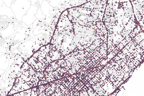
Traditionally, data are from road facilities that mainly belong to public administrations. From these data and population surveys, origin-destination matrices are extracted that provide information on where people start and finish their journeys in a certain city or area, during a fixed period of time.
The new sources of data from ICT open up a new paradigm and could contribute valuable information on mobility patterns, journey times and the origin-destination matrices. The MOBIDATA project explores sources from GPS tracker data to establish patterns of use of routes in a transport network, to infer the level of congestion or to obtain an origin-destination matrix. At methodological level, these data offer many opportunities. They not only provide information about the start and end of journeys, but also quite precise information on the routes that people take. Thus, it can be determined how many people are circulating on each street and in what types of vehicles they move, to identify the level of road congestion that exists.
Currently, work is being done on methodology to filter and process these data.
Other participants in the project are the German company PTV-AG. The budget is 15,000 euros and the project has taken 3 months (2021).
Technology
Sector
Topic
You want to know more?
Related Projects
- Researchers at the Universitat Politècnica de Catalunya - BarcelonaTech (UPC) have developed a unique infrastructure serving the UPC, research centres and companies for the experimentation and validation of technologies and services using next-generation networks. This platform enables the validation of 5G solutions in real-world scenarios and leads research towards 6G, facilitating technology transfer to the market.
- The Barcelona Innovative Transportation (BIT), the Research Center in Automotive and Advanced Mobility (CER-AMA) and The Future Mobility Research Hub (CARNET) research groups from the Universitat Politècnica de Catalunya - BarcelonaTech (UPC) are participating in the E-MED project, which aims to optimise energy and resource efficiency in public transport systems by addressing energy price fluctuations through smart and participatory solutions across the Mediterranean region.
- A research team involving the Barcelona Innovative Transportation (BIT), inLab FIB, CARNET Barcelona – Future Mobility Research Hub (CER-AMA), and the Department of Computer Architecture (DAC) of the Universitat Politècnica de Catalunya - BarcelonaTech (UPC) is driving the i-MovE project, which aims to incorporate multisectoral data to provide much more accurate and valuable information for the mobility sector. The project develops four use cases focused on both companies and mobility authorities, covering public and individual transport, using the UPCxels demonstrator.
- The Research Center for Supervision, Safety and Automatic Control (CS2AC-UPC) at the Universitat Politècnica de Catalunya - BarcelonaTech (UPC) has coordinated the SaCoAV project, focused on researching new methods and tools to ensure the safe coordination of autonomous vehicles in urban environments.


