
SMUFF: new instruments to better predict the impact of intense rain
December 1, 2019
An innovative system to validate and reconstruct flow meter data from the distribution network of Tarragona water consortium
December 12, 2019An urban heat island is a phenomenon that occurs when an urban area is much hotter than the surrounding undeveloped areas. It consists of an accumulation of heat due to urban activities and, above all, the mass of concrete and other heat-absorbing materials in a city. Urban heat islands accentuate the effects of global warming, resulting in climate change. The impacts have a negative impact on inhabitants’ health and comfort, and on the energy consumption associated with greater demands for cooling of urban spaces. These are aspects that get worse during the heat waves that affect Spain in an increasingly regular way.

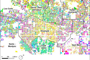
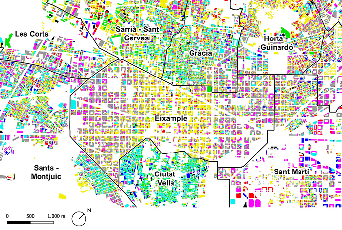
In this context, as part of the Urban-CLIMPLAN project, the Centre for Land Valuation Policy (CPSV UPC) has studied urban heat islands in Barcelona Metropolitan Area and the main factors that cause them. These factors include urban morphology, land uses, landscape design, the selection of materials and the location of vegetation. The analysis was completed with a series of specific case studies, such as that of Sant Cugat del Vallès, Sabadell Centre, Viladecans-Gavà-Castelldefels, urban parks in Barcelona and the UPC North Campus, which revealed different scales of definition of an urban heat island in this area.
Specific focuses of the project were the spatial distribution of land surface temperature (LST) and land surface air temperature (LSAT). The first was mainly analysed (at metropolitan scale) using models developed from information supplied by the Landsat and MODIS satellites. The second was analysed using information from weather stations. Due to lack of weather station data, models needed to be developed to find out about LSAT in more detail.
One main objective of the project was to identify night urban heat islands. The temperature at night is particularly relevant from the perspective of health, due to the greater vulnerability of the population. Urban-CLIMPLAN has developed a series of models to determine in detail the LST at night and highlight the areas that are most vulnerable in Barcelona Metropolitan Area.
The project was funded by the Ministry of Economy and Competitiveness and the European Regional Development Funds (ERDF), and the Spanish National Programme of Research, Development and Innovation Oriented to the Challenges of Society, 2015 call.The project was funded by the Ministry of Economy and Competitiveness and the European Regional Development Funds (ERDF), and the Spanish National Programme of Research, Development and Innovation Oriented to the Challenges of Society, 2015 call.
Related Projects
- The La Volta project foresees the construction of a large Catalan vault pergola within the Llars Mundet campus, in the Montbau neighbourhood (Horta-Guinardó district). This structure will become a new architectural landmark for Barcelona, combining traditional construction techniques with contemporary innovation. The project involves the Rehabilitation and Architectural Restoration Research Group (REARQ), at the Universitat Politècnica de Catalunya - BarcelonaTech (UPC), and is led by the Architects’ Association of Catalonia (COAC) and the Barcelona Provincial Council.
- The Architecture, Energy and Environment (AiEM) research group at the Universitat Politècnica de Catalunya - BarcelonaTech (UPC) has characterised Barcelona’s residential buildings according to their capacity to adapt to climate change. This study is part of the project ‘VeUvE: Urban havens for vulnerable zones’. The work highlights the climate inequality conditions present across different areas of the city and will help to better define the priorities and energy renovation strategies for its districts.
- The Research Center for Supervision, Safety and Automatic Control (CS2AC-UPC) at the Universitat Politècnica de Catalunya - BarcelonaTech (UPC) has coordinated the SaCoAV project, focused on researching new methods and tools to ensure the safe coordination of autonomous vehicles in urban environments.
- The Centre for Technological Risk Studies (CERTEC) at UPC is participating in the WUITIPS project (Wildland-Urban-Interface Fire Touristic Infrastructure Protection Solutions), which aims to develop a new wildfire management framework for the tourism sector. This project contributes to risk analysis and the design of specific strategies to mitigate such risks.


